Features
Details
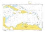
Embark on your nautical adventures equipped with the best navigational tool - the NGA Chart 402. Crafted with precision on Water-Resistant PaperTyger, this lightweight and tear-resistant chart ensures durability and reliability in the unpredictable elements of the North Atlantic Ocean and Caribbean Sea. Say goodbye to soggy, illegible charts and hello to a smooth matte paper feel that withstands the test of nature!
Experience the power of up-to-date cartography in your hands with the NGA Chart 402. Printed on demand using the latest files from the National Geospatial-Intelligence Agency, this chart guarantees accuracy and clarity in every detail. As a certified NGA reseller, we ensure that you have access to authentic and vetted navigational aids that meet the highest standards of quality and precision.
Don't compromise on safety and reliability when it comes to your nautical expeditions. The NGA Chart 402 boasts a scale of 1:2,750,000 and a spacious size of 45 x 32 inches, offering comprehensive coverage of the intricate marine landscapes of the North Atlantic Ocean and Caribbean Sea. Trust in the expertise of East View Geospatial to deliver a top-tier navigation tool that guides you through even the most challenging waters with ease!
Enhance your maritime journeys with the unparalleled accuracy and durability of the NGA Chart 402. Navigate confidently through the vast expanse of the North Atlantic Ocean and Caribbean Sea, knowing that you have a reliable companion by your side. Order your copy today and embark on a seamless and secure voyage to new horizons!
Discover More Best Sellers in Marine GPS Accessories
Shop Marine GPS Accessories
Garmin 010-11580-00 NMEA 2000 Power Isolator Yellow, Small

 Marine GPS Accessories - Garmin 010-11580-00 NMEA 2000 Power Isolator Yellow, Small
 Marine GPS Accessories - Waterproof Charts, Standard Navigation 30 Puget Sound, Easy-to-Read, Waterproof Paper, Tear Resistant, Printed on Two Sides, 2 Charts in 1, NOAA Charts

Raymarine Raynet Cable Puller (5 Pack)
Marine GPS Accessories - Raymarine Raynet Cable Puller (5 Pack)

Garmin Transducer Adapter Cable - 12-Pin, 010-12098-00
Marine GPS Accessories - Garmin Transducer Adapter Cable - 12-Pin, 010-12098-00
 Marine GPS Accessories - MotorGuide 8M0092071 Xi Series Pinpoint GPS Navigation Remote Replacement — For Xi3 and Xi5 Trolling Motors Includes Lanyard
 Marine GPS Accessories - Yacht Devices Boat NMEA 0183 to NMEA 2000 Gateway (YDNG-03N) for Yacht and Boat Network - NMEA 2000 Micro Male
 Marine GPS Accessories - 010-12006-11 Replacement Transom Mount with Spray Sheild Compatible with Garmin Echo, EchoMap, GPSMAP, GT 4pin, 8pin, 12pin Transducer - Easily Attach Transducer Mounting Bracket for Garmin Units
 Marine GPS Accessories - Blink Mini 2 — Home Security & Pet Camera with HD video, color night view, motion detection, two-way audio, and built-in spotlight — 1 camera (White)

